The Potawatomi are a North American tribe of indigenous people that were originally located in the Great Plains, near the Great Lakes region. As white European settlers kept expanding towards the Mississippi River, many Native American tribes were forced out of their homelands. Indigenous people ceded more and more of their land through treaties and war with their white “neighbors.” The Indian Removal Act of 1830 was signed by President Andrew Jackson to promise land west of the Mississippi to Native Americans that agreed to give up their homelands. These tribes were persuaded, bribed, and threatened into signing these removal treaties to “open millions of acres of rich land east of the Mississippi to white settlers” (Indian Treaties and the Removal Act of 1830). The Potawatomi were removed from their homelands due to the 1833 Treaty of Chicago (ratified in 1835) and most of the tribe was forced to relocate to present-day Kansas and Oklahoma by 1838 (Potawatomi Treaties and Treaty Rights).
The Potawatomi subagent was named Dr. Edwin James. He coordinated with the “Indian Bureau” of the War Department to force the Native Americans from the Great Lakes region to their temporary location at Fort Leavenworth. The Platte Purchase expanded the land of Missouri and forced the Potawatomi to move again. Later, Brigadier General H. Atkinson of the War Department assisted James in moving them to “a point on the Missouri river fifteen or eighteen miles above the mouth of the great Platte river” (Babbitt 27). About 100 Potawatomi members who could not march were loaded aboard the steamer “Kansas” and arrived at the spot on July 28, 1837. Another trip on the steamer “Howard” brought an additional 75 Potawatomi to the spot on August 11, 1837. The rest of the tribe arrived with Captain D. B. Moore of Company C of the First Regiment of Dragoons when his superior, Colonel S. W. Kearny, ordered him to escort the group of Potawatomi Native Americans and “take a position…near the [Missouri] river…not far from 'Belle View'” (Babbitt 52). This occurred sometime in late August 1837. Overall, the total number of Potawatomi who came to the area of present-day Council Bluffs “never exceed[ed] 3000” (Babbitt 28).
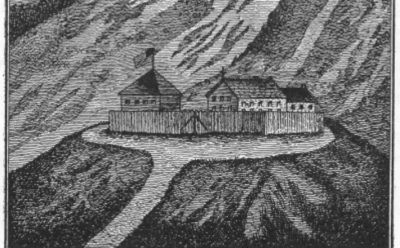
Sourced from Early Days at Council Bluffs by Charles Babbitt.
Once a site had been chosen, Moore was ordered to construct a blockhouse “of one story, about 25 feet square, at such place as you may deem eligible, with a sufficient number of loop holes, which will serve as a hospital for any sick you may have and as a storehouse for your provisions” (Babbitt 52). After its construction, Moore marched his men back to Fort Leavenworth and Billy Caldwell (aka Sauganash) then occupied the area of the blockhouse and it became known as Caldwell’s village. Caldwell was an appointed chief of the United Nations of Chippewa, Ottawa and Potawatomi who helped negotiate the Treaty of Chicago in 1833 and came with the Potawatomi in 1837. In May of 1838, Caldwell allowed Jesuit missionaries Father Pierre-Jean De Smet and Father Felix L. Verreydt to use three small cabins near the fort and occupy the blockhouse to establish the mission of St. Joseph (also referred to as St. Mary) to proselytize to the Native Americans. In 1839, the missionaries erected a dwelling that “served as [a] church or chapel, school and residence for the missionaries“ (Babbitt 32). Father De Smet was sent on another mission in 1839 and the “Jesuit Pottawattamie Mission at Council Bluffs” was abandoned in July or August of 1841 (Babbitt 57).
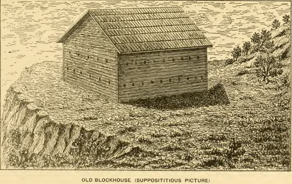
It appeared in Dexter Bloomer's article on the old blockhouse from the Annals of Iowa in 1896.
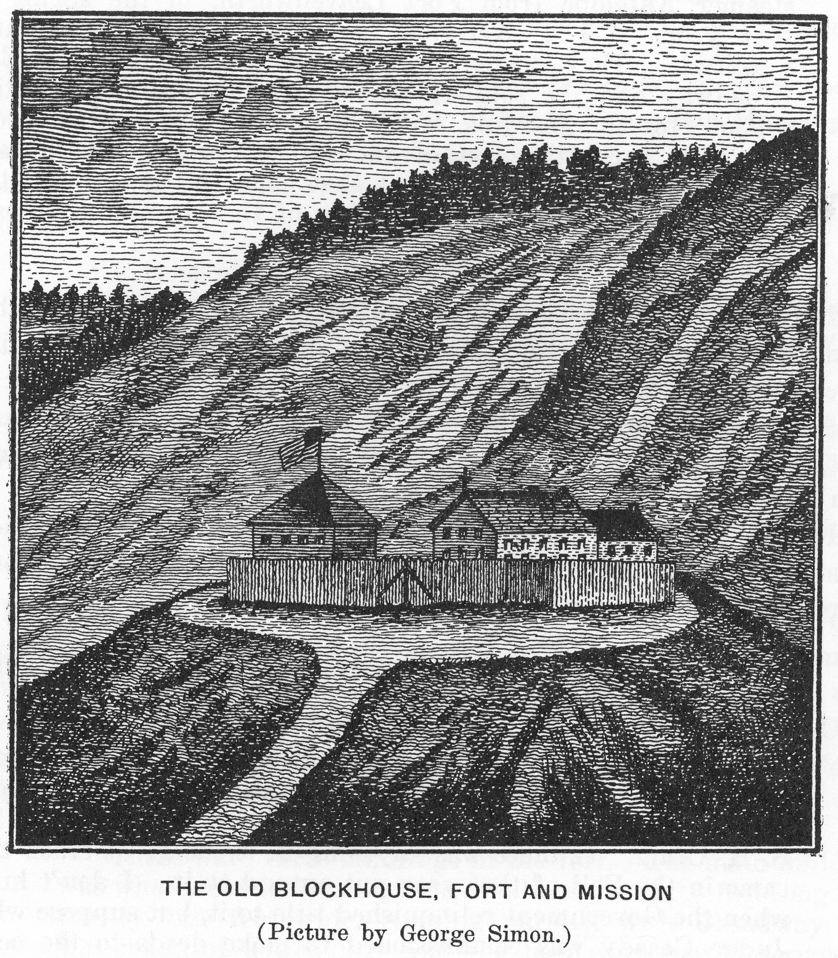
There are many descriptions of what the old blockhouse (also referred to as “old fort” and “old mission”) looked like and how the buildings were configured. These mostly come from the memories of residents of Council Bluffs because little existed in the official record regarding the blockhouse. Charles H. Babbitt included a drawing of what he thought the blockhouse would have looked like in 1837. George Simons, a prolific frontier artist, sketched the old blockhouse from memory but it is undated. As a teenager, Henry De Long traveled with the Mormons to the site of Council Bluffs in 1846 and remembered three buildings in the fort. The main building was “sixty feet long and twenty-four feet wide, running parallel to Broadway…There was a building just west and south of the main building, built in the form of a chapel…There was a small one-story building back of the fort, to the east…might have been officers’ quarters” (Babbitt 47). De Long was later shown the undated sketch by George Simons and said “with the main building I speak of torn down, the picture is probably a fair representation of the fort in 1855” (Babbitt 48).
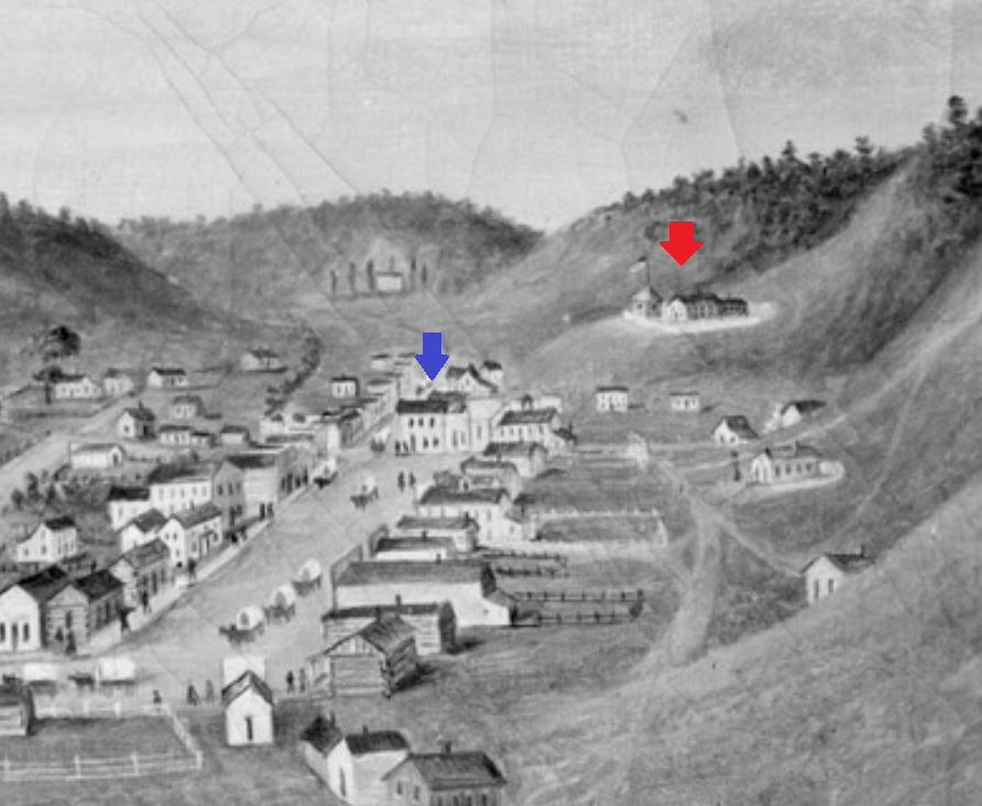
The old blockhouse is indicated by the red arrow in the upper right. For reference, the blue arrow shows the location of the Ocean Wave Saloon (present-day Broadway Methodist Church) at the head of Broadway Street.
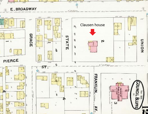
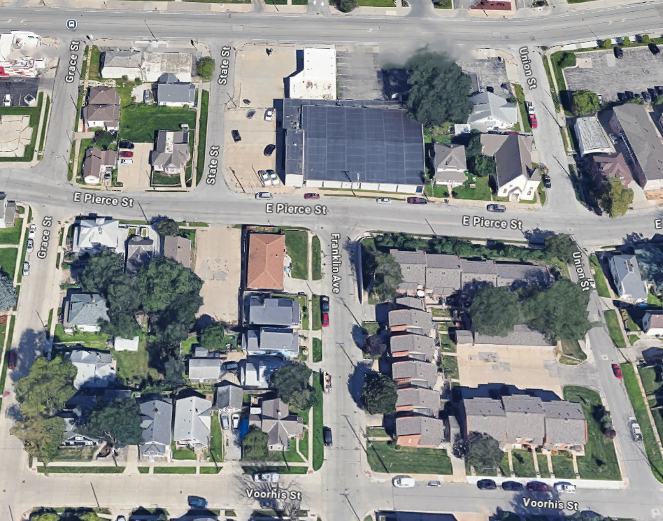
Historical markers placed by the Pottawattamie County Historical Society in 1971 indicate the location of the old blockhouse. There are two markers on the south side of East Pierce St, one at the corner of Franklin Ave and the other at the corner of Union St. H. H. Field, coauthor of the book History of Pottawattamie County, Iowa, explained that the area of the old blockhouse “consisted of nearly all the square bounded by Broadway, Grace, Union and Pierce streets” (Babbitt 46). The area looked much different from today as shown in the painting by George Simons from 1853. The painting includes the old fort and gives us a good idea of where it was located. Dexter Bloomer, in his article about the old blockhouse in the Annals of Iowa, stated when he came to Council Bluffs "in 1855, these buildings (in the undated George Simons sketch)...were yet standing, but used merely for storage purposes" (Bloomer 551). By 1857, the old blockhouse was demolished. It was slated to become the site of a new hotel for "upper" Broadway. Babbitt explained that the site of the former blockhouse "was cut away so that a precipitous bank something like thirty feet high formed the south line of Pierce Street" (Babbitt 44). However, the hotel never materialized. Interviewed around 1916, H. H. Field recounts that "John Warner was the first that owned [the lot] to my knowledge as he employed me to fence it, and John Clausen the last, as I worked on his dwelling some forty years ago" [circa 1874] (Babbitt 46). The Clausen residence was torn down in 1954 and was near the current site of In Motion Gymnastics at 15 State St. The Pierce Street School, constructed in 1884, likely occupied part of the ground where the old blockhouse was positioned. The school was demolished in 1956.
The old blockhouse was situated south of Broadway between Grace and Union streets.
It would have likely included land where the Pierce Street School was located (lower right) based on Babbitt's description of the grading for the hotel.
Sources:
Babbitt, Charles H. Early Days at Council Bluffs. Press of Byron S. Adams. 1916.
Bloomer, D. C., (1896) “The Old Blockhouse in Council Bluffs”, The Annals of Iowa 2(7), 549-552. View Source.
Field, Homer Howard, and Joseph Reed. History of Pottawattamie County, Iowa, from the earliest historic times to 1907. The S. J. Clarke Publishing Co., 1907.
“Indian Treaties and the Removal Act of 1830.” Office of the Historian, Foreign Service Institute, United States Department of State, View Source.
“Potawatomi Treaties and Treaty Rights.” Milwaukee Public Museum, View Source.